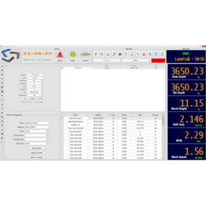
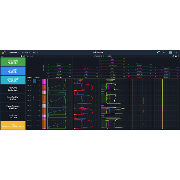
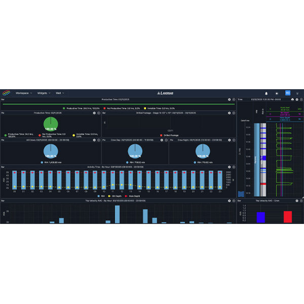
WITSMLTM DATA ANALYZER WellNode

WITSMLTMdata analyzer with dashboard visualization for RTOCs.

Target Application: Real-time Operating Center, Remote monitoring

Description: Wellnode is a dashboard-based visualization and analysis application built to monitor one or multiple wells in real-time. It supports WITSMLTMand ETPTM data coming from any source – EDR, Mudlogging unit, Directional Drilling, Managed Pressure Drilling, Logging while Drilling, among other. Users can create dynamic dashboards in a Real-time Operating Center (RTOC) to closely manage their wells, gain insights, and create reports.

Capabilities include:

  • Real-Time WITSMLTMdata visualization
  • Support for WITSMLTMv 1.3.1.1 & 1.4.1.1
  • Customizable dashboards
  • Key Performance Indicators (KPIs) dashboard
  • Alarms Module
  • Time & Depth-based exportable reports
  • Wellbore visualization
  • Operational Limits
  • Lithology
  • Engineering Analysis
  • Predictions
APPLICATION INFO
Dashboards: Pre-defined template
User-defined and editable
Access: 
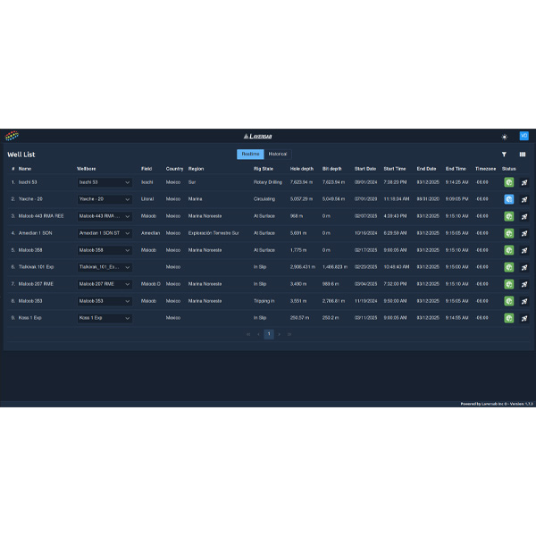
Real-time & Historical
Multiple well access simultaneously
Alarms: Visual
Email
Configurable
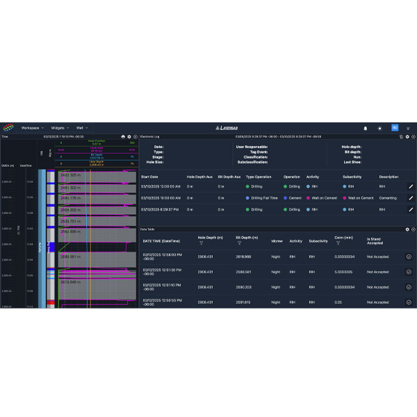
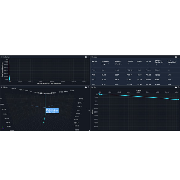
Wellbore Visualization: 2-D & 3-D
MWD/LWD Correlation
Reports: Time-based or Depth-based
Quick Report PDF
Detailed Report - Excel or PDF
Modules: Operational Limits
KPIs
Lithology
Engineering
Predictions
Units: Metric & Imperial; configurable per variable
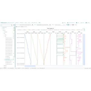
SYSTEM INFO
Software type: Web Platform
Classification: Data visualization in Real-Time
Lifecycle status: In Production
Language: English & Spanish
Web browsers supported: Chrome (recommended), Edge,
Firefox, Safari
Device compatibility: Desktop and laptops computers
Protocol compatibility: ETP v1.1, WITSMLTM v1.4.1.1,
WITSMLTMv1.3.1.1
Test Set Type

Air Data Ramp

Aircraft Type

Business Jet, Commercial, Helicopter, GA, & Non-RVSM

RVSM Capable

Yes

Max Aircraft Altitude

50,000 ft, 60,000 ft

Max Aircraft Airspeed

500 knots, 600 knots, 650 knots, 690 knots

Number of Channels

2

Target Application

Business Jet & Commercial

Range

-2,000 to 60,000 ft

Resolution

1 foot

Accuracy

2 ft. @ 0 ft. 3 ft. @ 10,000 ft. 4 ft. @ 20,000 ft. 6 ft. @ 35,000 ft. 12 ft. @ 50,000 ft.

Rate

0 to 500 knots/min

Remote controller

Standard

Wi-Fi

Standard, Yes

RS-232 interface

Standard

IEEE-488 interface

Not Available

Encoder input

Optional

28 VDC Power

Not Available

Battery

Optional, Yes

Heaters

Optional

Warranty

3 Years

Displayed Static Units

feet, meters, inHg, mbar, psi, mmHg, kg/cm2

Displayed Pitot Units

knots, Mach, kmph, mph, inHg, mbar, psi, mmHg, kg/cm2, EPR

Power Requirement

90-260 VAC, 47-400 Hz, 100 W (200W with Heaters)

Dimensions & Weights

22" x 14" x 9" / 34 lbs.

Calibration Interval

Annual

Operating Temp.

0°C to 50°C

Optional Temp Ranges

-40° C to 50°C

Humidity (non-condensing)

5 to 100%

Altitude capability (ft)

50,000 ft, 60,000 ft

Airspeed capability (knots)

500 knots, 690 knots

Wide Temp capable

Yes

Battery/Wi-Fi capable

Yes

Capability

Battery/Wi-Fi, RVSM Capable, Wide Temp

Range socf

0 to 15,000 ft./min

Accuracy socf

1% of Rate

Resolution socf

1 ft./min

Range poaf

0 to 690 knots

Rate poaf

0 to 500 knots/min

Resolution poaf

0.1 knot

Accuracy poaf

0.04 knots @ 500 knots, 0.1 knots @ 200 knots, 0.2 knots @ 100 knots, 0.3 knots @ 50 knots, 1.0 knots @ 20 knots

comparison_order

2

You may also like…

  • WITSMLTM& ETPTMSERVER WITSMLTMStore

    Cloud-based WITSMLTMserver

    Target Application: Data managerment, Well data storage

    Description: WITSMLTM Store is a cloud-based software solution to store and manage data coming from the rig. It can be used with data sources like Laversab LINKS or from other WITSMLTM sources. Any WITSMLTMvisualization tool – including Wellnode – can be used to visualize and monitor data from WITSMLTM Store.

    WITSMLTMStore is compatible with WITSMLTMv1.3.1.1 and 1.4.1.1. It also supports ETP v1.1, ensuring high-performance and reliable data delivery. WITSMLTMStore can be used to securely connect and manage data from any well at any time, and it provides assurance that well data will not be lost. Local instances can be installed if required.

    Capabilities include:

    • Admin Panel
    • Rig/Well/Wellbore Management
    • Client/User management
    • Data Quality check
    • Data gap Finding and Manual gap filling(CSV/LAS Patching)
    • UI for verifying Time and Depth Log
    • Rig/Well online/offline Status
    • Client/Consumer online/offline status
    Read more
  • ELECTRONIC DRILLING RECORDER Portable EDR

    Data acquisition system for drilling rigs. Real-time surface paramaters.

    Target Application: Work-over rigs, Land rigs, Offshore drilling rigs

    Description: The Laversab EDR is a data acquisition system with purpose-built software to monitor surface parameters in real-time. It designed for multiple applications on the drilling rig, including Depth Logging, Mudlogging, Lithology, Pit Volume Totalizer (PVT), and more.

    The EDR makes real-time surface parameters available to the driller, operator, and offsite stakeholders. Key Performance Indicators, Tour Sheets, and Daily Reports are generated by the LINKS EDR Software. The system works with typical surface measurement sensors, which can be reused across multiple jobs.

    Customers can select the number of channels, junction boxes (JBs), sensors, and cables they require for each system. Rigs with existing sensors and hardware can be updated to use the Laversab EDR. This system is highly portable and can be relocated after a job is completed.

    Read more
  • WITS0 to WITSMLTMCONVERTOR LINKS COLLECTOR

    Convert all drilling data to WITSMLTM.

    Target Application: Land rigs, Offshore rigs, Work-over rigs

    Description: Laversab LINKS Collector can convert all drilling data to WITSMLTM.

    WITSMLTMversions 1.3.1 & 1.4.1 are currently supported.

    LINKS Collector can handle most data formats – from WITS0 to proprietary formats used by equipment companies. LINKS Collector is a low-footprint software that can run on any rig system. It can also act as a data aggregator by correlating data from multiple rig sources.

    Read more
Scroll to Top